Bangor sits on a complex mix of glacial till overlying Ordovician mudstone and siltstone of the Gwna Group, with alluvial pockets along the Menai Strait. Compaction control here is never routine — the tills can be stony and variable, and near the coast, groundwater tables are high enough to complicate backfill placement. When the local council or NHBC requires proof of relative density on a trench reinstatement or structural fill, we deploy the sand cone method as the direct field check. The procedure follows BS 1377-9:1990 for the sand replacement technique, and we routinely combine it with a Proctor test to establish the reference maximum dry density. In Bangor’s mixed geology, a single Proctor curve may not represent the entire site, so sampling across each material zone becomes essential before any density acceptance is signed off.
A sand cone result above 95 % of the Proctor maximum dry density — with a moisture content within ±2 % of optimum — is the difference between a pavement that lasts twenty years and one that fails in two.
Method and coverage
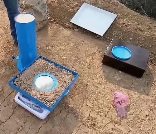
The apparatus we use on Bangor sites is a calibrated sand pouring cylinder with a standard 100 mm or 150 mm diameter cone base plate, depending on the maximum particle size encountered. For the stony glacial tills common on the hillside developments around Upper Bangor, the larger plate avoids bridging errors. The cylinder is filled with clean, single-size Leighton Buzzard sand — specified in BS 1377 for its uniform grain shape and minimal volume change during pouring. On a typical trench reinstatement in the Hirael area, where the natural ground is soft alluvium, we excavate a test hole to the full lift thickness, carefully collect all soil, seal it in a moisture-tight bag, and run the sand flow. The difference in sand weight, corrected by the cone calibration factor, gives the field density directly. Each test point is tied to a GPS coordinate and referenced to the lift number, so the earthworks contractor can track compaction trends across the site in near real time. Where the fill contains oversize cobbles — not unusual in glacial deposits — we apply the rock correction procedure from BS 1377-9 to adjust the measured density, preventing the rejection of otherwise competent material.
Regional considerations
Compaction acceptance on the glacial till slopes of Upper Bangor and the soft alluvial flats near the Menai Strait present two completely different failure modes. In Upper Bangor, the till contains angular clasts up to 150 mm — if the contractor does not remove oversize material from the test hole, the measured density will be artificially low, and the whole lift gets scrapped unnecessarily. Down in Hirael, the groundwater is barely 1.5 m below ground level, so trench backfill placed without dewatering ends up at moisture contents well above optimum. A sand cone test that shows 88 % relative density here is not a compaction failure — it is a drainage failure. We flag the difference immediately. The most expensive mistake we see in Bangor is accepting density results from a borrowed Proctor curve that does not match the fill actually placed. When the structural engineer later calls for CBR testing and the values are half of what was assumed, the pavement design unravels. The sand cone test is simple physics, but interpreting it correctly on Bangor soils means understanding the geology, not just the numbers on the worksheet.
Q&A
What does a field density test by the sand cone method cost in Bangor?
A single sand cone test in the Bangor area typically ranges from £70 to £130 per point, depending on access constraints and whether the laboratory Proctor reference is already available. A full-day programme of six to eight tests, including a site-specific Proctor curve, will fall at the higher end of the range per point when mobilisation and reporting are factored in.
How many sand cone tests are needed on a typical Bangor housing development?
The Specification for Highway Works recommends a minimum of one test per 500 m² per compacted lift. On a two-hectare residential site with 300 mm lifts, that can easily mean 40–50 tests across the formation, sub-base, and road capping layers. We tailor the frequency to the earthworks spec and the variability of the fill — glacial till sites often need tighter spacing than uniform sand fills.
Can the sand cone method be used on stony glacial till in Bangor?
Yes, with the correct procedure. When the till contains particles larger than 37.5 mm, we use the 150 mm diameter cone plate and apply the rock correction method from BS 1377-9. Oversize material is removed from the test hole, weighed, and its volume calculated so that the density of the matrix soil is not penalised by the presence of large, competent clasts.
How soon after compaction can the test be performed?
The test can be carried out immediately after the compactor passes, provided the surface is stable enough to seat the base plate without disturbance. There is no curing or waiting period required, which is one reason the sand cone method remains the most practical field check during active earthworks in Bangor.
What is the difference between a sand cone test and a nuclear density gauge?
The sand cone method measures density directly by excavating and weighing soil, while a nuclear gauge infers density from radiation scattering and requires site-specific calibration against a sand cone reference. On Bangor's stony tills, the sand cone is often the preferred primary method because the gauge can give erratic readings on coarse, heterogeneous fills. The trade-off is that each sand cone test takes 20–30 minutes versus a few minutes for a gauge reading.