A recent project on the slopes near Penrhosgarnedd required rapid assessment of fill depth over the native glacial till. The developer needed to know if the Victorian-era rubble just below the surface would support a two-storey extension. In Bangor, the ground profile can change within metres—from dense till to soft alluvium along the Adda river corridor. We opened four exploratory test pits in a single morning, logged the strata according to BS 5930, and delivered the report within two working days. That kind of turnaround is what local builders and architects rely on to keep projects moving. The test pit remains one of the most cost-effective ground investigation techniques available, especially when combined with targeted SPT drilling in areas where the excavation depth exceeds safe trenching limits. In a city wedged between the Menai Strait and the Snowdonia foothills, surface evidence rarely tells the full story.
A well-executed test pit in Bangor reveals more about the ground in one hour than a desktop study can in a week.
Regional considerations
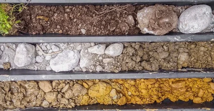
The contrast between Upper Bangor and the lower-lying Hirael area illustrates the risk of skipping a site investigation. Upper Bangor sits on stiff, stony glacial till that offers excellent bearing capacity, often exceeding 200 kPa at shallow depth. Hirael, built on estuarine deposits along the shoreline, contains soft silty clays with organic layers that compress under load. A foundation design suitable for one area would fail in the other. We have seen extensions in Hirael where differential settlement cracked the masonry within two years because the designer assumed uniform ground conditions. An exploratory test pit, properly logged and sampled, eliminates that guesswork. The cost of excavation is negligible compared to the remedial underpinning work that results from assuming the ground is consistent across a city built on such varied geology.
Q&A
How much does an exploratory test pit cost in Bangor?
For a single test pit excavated in accessible ground within the Bangor area, the cost typically ranges from £340 to £610. The final figure depends on depth, access for the excavator, spoil removal requirements, and whether laboratory testing is needed on the recovered samples. We provide a fixed-price quote after reviewing the site location and the scope of the investigation.
What depth can a test pit reach in the glacial till around Bangor?
With a standard 3-tonne excavator, we routinely reach 4.0 to 4.5 metres in the dense till that underlies much of the city. For deeper investigation, we can step the excavation to reach approximately 6.0 metres, though this requires more space and trench support. If the target depth exceeds this, we recommend supplementing the pits with a borehole investigation using dynamic sampling or rotary coring.
Do I need a test pit if I already have a borehole log from a neighbouring property?
Not necessarily, but in Bangor we rarely rely on off-site logs alone. The glacial and alluvial deposits here are notoriously variable—two boreholes 20 metres apart can encounter completely different sequences. A test pit provides a continuous exposed face that reveals lenses of soft material, old drainage features, or buried walls that a borehole might miss. It is the most reliable way to verify conditions directly beneath your proposed foundation footprint.